 |
Hempstead |
|
Village History |
||||||||||||
|
Lose Hall what3words location - ///raft.bagpipes.ranches |
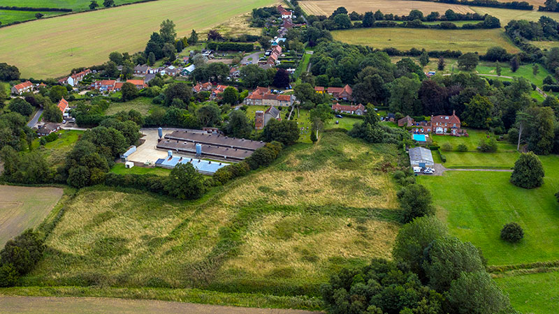 |
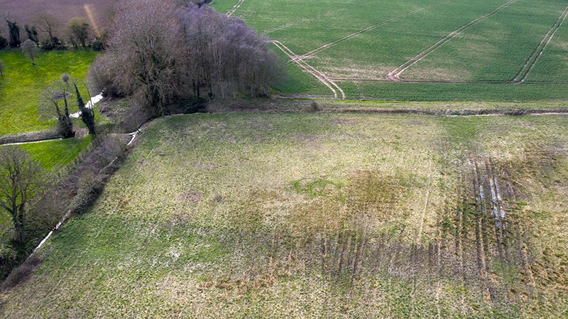
31st August 2019 The outline of the presumed moat around Lose Hall can clearly be seen, forming a square, lower centre. Site of old fishpond visible lower left. |
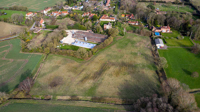 |
11th March 2020 The outline of the presumed moat is visible in lower, damper soil, forming a square, lower centre. Site of old fishpond clearly visible lower left. |
The lords of the manor of Hempstead in latter years, were actually the lords of two manors within the parish, not three, as indicated by a punctuation error. However, these manor houses are long gone - Lose Hall and Nether Hall. H. and R. H. Gurney Esqrs., are lords of the manors of Hempstead, Netherhall, and Losehall. White's 1845 |
When reading the directory_entries, one factor that has been perpetuated by all the directories should be taken into account - . . . other people's mistakes inevitably get perpetuated. The editor of Whites 1845 Directory intended to say that H and RH Gurney were Lords of the Manor of Hempstead Nether-Hall and Hempstead Lose-Hall. Unfortunately the printer seems to have interposed a comma so the entry reads ''Lords of the Manor of Hempstead, Nether-Hall, and Lose Hal1.'' Ever since then it has been assumed (quite wrongly) that Hempstead had three manors. Extraordinary efforts have been made to identify the third one ("Hempstead'') by putting it in the Pond Hills woods towards Edgefield connected to Hempstead Hall by a tunnel. Hempstead, A Norfolk Village - Robin Carver, 2000 |
Lose-Hall After this, it was in the priory of Norwich, in the 9th of Edward II (1316). who, in the first of Richard III (1483). grant it to Henry Heydon, on his releasing to them certain lands in Hindringham, who died lord, as did John Heydon, in the 19th of Edward IV (1480). The manor-house, now demolished, stood in a close adjoining to the church. Sir Christopher Heydon held it at his death, in 1579; his son, Sir William, in the 34th of Elizabeth (1592), assigned it to Thomas Fermor, Esq. of East Barsham, for payment of debts, and soon after, Thomas Croft, Esq. and Thomas Oxburgh, Esq. had a prcipe to deliver it to Edmund Stubbe, Esq. and Thomas Thetford, Esq. An Essay Towards A Topographical History of the County of Norfolk: Volume 9 Originally published by W Miller, London, 1808 |
Hempstead Lose and Nether Halls |
||||||||||||||||||||||||||||
In pre-historic times the central part of the Parish was inhabited, as can be attested by Mr Bertie Harmer who has found many flint tools on his land at Green Farm. |
||||||||||||||||||||||||||||
|
||||||||||||||||||||||||||||
The Newmans were the first lords of the manor to have lived locally and have left tombstones. They lived at Baconsthorpe Manor and were buried in Baconsthorpe Church. They flourished but briefly. Thomas was born in 1623 and died in 1697 and by his marriage to Elizabeth he had two children, Thomas who died aged 21 in 1698 and Elizabeth who died aged 20. The lordships therefore went in 1698, following his death, to William, the second of that name, and possibly Thomas's nephew. William had only one child, a daughter Elizabeth who died in 1714. So, deprived of heirs, the Newmans lost their land and the Lordship when they sold in 1728. |
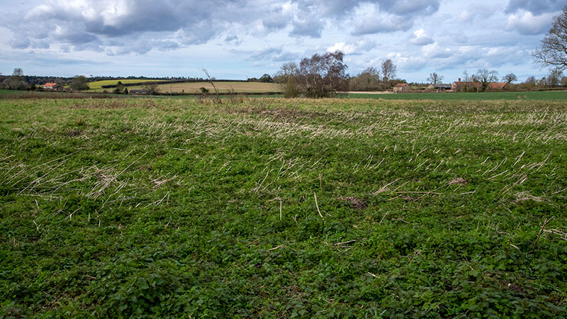 |
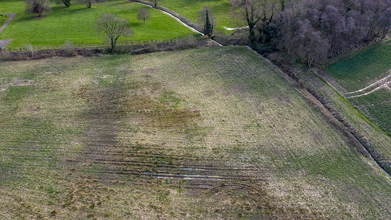
Lose Hall moat looking north - 11th March 2020 Ground slightly depressed with a damp soil structure and profuse growth of nettles |
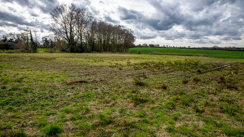 |
Northeast corner of moat - 11th March 2020 |
 |
Lose Hall moat clearly outlined looking west - 11th March 2020 |
 |
Lose Hall moat with its feeder stream coming in from the south - 11th March 2020 Due to agricultural drainage, the stream depth is now much greater than when it supplied the moat years ago. The stream has also been straightened in modern times in order to improve flow and assist maintenance. |
Lose Hall |
|
1968 |
Moated site of great house or manor discovered. Footings of flint and mortar found and causeway? running northeast from site. Square platform to east. Is this Loose Hall? |
Survey - March 1975 |
Stream fed rectangular moated enclosure with fishpond to northwest. Part of a late medieval floor of glazed and impressed tiles appearing to survive in situ over a considerable area. |
Sept - Oct 1975 |
Destroyed by ploughing |
8th October 1975 |
Soilmarks surveyed. Hole in southeast part of interior showed floor of glazed impressed tiles, 14th to 15th century in situ within roughly rectangular area of late medieval brick rubble. |
8th - 29th Sept 1976 |
Twin destroyed moated enclosure. Building around 14m by 5.5m. Flint and mortar walls almost robbed. Three rooms identified, two with floors of relief tiles. One internal cross wall of bricks, the other of clay. Twenty one types of relief tiles, some of which are heraldic. One plain type and one example of a printed tile. Unknown source of manufacture, definitely not Bawsey. Ditch and pits sealed by floor. Very little pottery but seem to be 12th to 13th century. Linear feature in black soil and potboilers may have been prehistoric. If site was Loose Hall it was occupied from late 13th century to 15th century. Tiles could be 14th century but not definite. |
| Norfolk Heritage Explorer | |
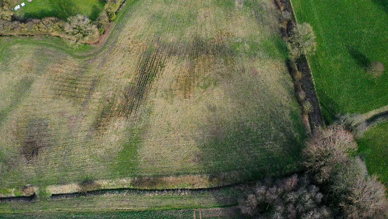 |
Lose Hall moat with the fishpond lower left clearly outlined looking east - 11th March 2020 |
In East Anglian Archaeology Report No 8 (Norfolk) Andrew Rogerson and Nick Adams have written a fascinating report on the excavation of the moated site to the south-west of the church which they concluded was the site of the lost medieval Lose Hall. ln that report they considered also the possibility of the site being that of the original vicarage and recorded the following information:- Rogerson goes on to state ''The Glebe Terrier of 1613 places the vicarage to the south of the church and between the road and the manor close and described it as "a dwelling house and a barne with one little outhouse . . .'' So somewhere underground to the west of the village playground there must still be the foundations of the original vicarage, its “barne'' and outhouse. Presumably it was Robert Watson, vicar between 1599 and 1649 but also Vicar of Bodham and Baconsthorpe, in one of which villages he may have lived, who let the former vicarage fall down so that since the mid-l7th century to 1876 there was nowhere in the village for the vicar or (unless he took lodgings) for the curate to live. |
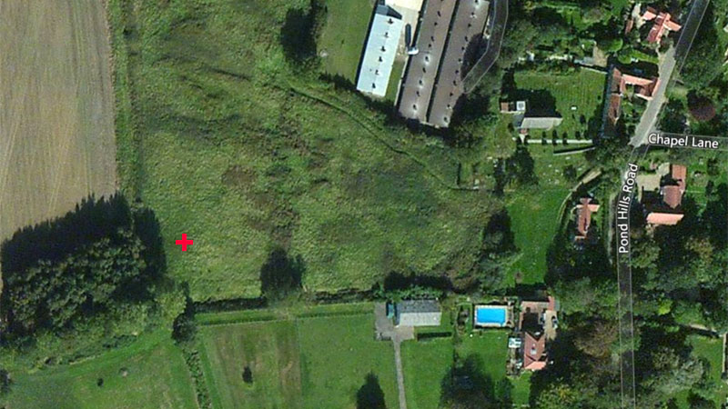 |
Probable site of Lose Hall according to grid reference detailed by Norfolk Heritage Explorer Courtesy of Microsoft map images |
I believe that the manor was still in use as late as October 1668 per record NRS 11952, 27A4 in which William Brettingham's brother Thomas declares that his brother Wm. was dead (not true) and Thomas claimed the inheritance, being the 4 acres behind Church_Farm (bottom of Clamp Lane) our property. This statement was made to "the general court of Thomas Berney Esq., Lord of the Manor, the steward being Thomas Bacon, Esq. at the Manor of Hempstead Loosehall." Kim Baynard - 22nd October 2022 |
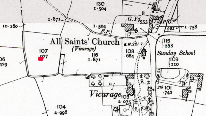 |
O. S. Map 1905 Probable site of Lose Hall as detailed by Norfolk Heritage Explorer marked in red Courtesy of NLS map images |
If you have any memories, anecdotes or photos please let us know and we may be able to use them to update the site. Please
or telephone 07836 675369 |
Website copyright © Jonathan Neville 2020 |